Tuesday, June 28, 2011

June 26th-28th Travel Days with a stopover in Grand Mesa

June 26th Lakeview through Blue Mesa Recreational Area & Black Canyon to Grand Mesa
Today we left Lakeview and the Gunnison National Forest, traveled through Blue Mesa Recreation Area and then took the North rim of the Black Canyon up to Grand Mesa National Forest.

Blue Mesa Recreation Area

Gunnison River as it winds through Black Canyon with the San Juan mountain chain in the background.

Colorado traffic jam on the way to Grand Mesa.

The trip up to Grand Mesa took a little longer, Due to the steepness and altitude climb, we had to let the RV cool down two different times … the engine and transmission ran hot, warning gauges are a good thing. The views were worth the wait, this is just one of the many lookouts near the top of Grand Mesa.
Island Lake, one of the many lakes we passed on the way to Jumbo campground (which had just opened last week, due to snow).
June 27th Jeeping out to Land’s End and Crater View
Today we headed out to see the back country of Grand Mesa. This is the view from Land’s End

While at the observation point, Lars met Chip and Dale who loved the sunflower kernels he had to offer.

 From Crater View you are able to see Land’s End which is a large mesa/peninsula that you are able to look and see Grand Junction below.

After leaving Crater View we headed down the rough, 4X4 trail only to find patches of snow. Hmmm…it was a little too much snow for the (blue mule) jeep…yes, stuck again. The mud puddles were fine, but not the hard packed snow. Three of four wheels had no grip, since the frame of the jeep was resting on top of the snow. No handy shovel or gloves to speak of…until some nice ATVer’s came and helped bail us out. Lets just say we struggled for about an hour and half.

We came down from Grand Mesa (10,000ft) to Highway 70 (5,000ft) where it was in the mid 90’s, yuck.
However the scenery on Highway 70 around Glenwood is stunning with the steep rock walls on both sides and the Colorado River flowing along aside, it is definitely a great view. You also get to tunnel through the mountains, which felt somewhat cooler.


Saturday, June 25, 2011

June 23rd - 25th Exploration of Gunnison National Forest


June 23rd  - We'll be Home for Dinner or NOT
We left the RV bright eyed (7:30am) and ready for day of Jeeping and hiking. Copper Lake (elevation 11,350)via the Copper Creek Trail was our destination, where we would do an 8.5 mile (round trip) hike.  The brochure said, “Famous hike with a gradual ascent. Pristine alpine lake awaits.” This was also considered to be moderate level hiking experience… no problem! Besides we hiked 17 miles to see half dome in Yosemite and that was marked as a strenuous hiking level of difficulty.
On our way we passed through Crested Butte, a ski town with eclectic shops, eateries and beautiful scenery.

In order to get to the parking lot of the Copper Creek Trailhead, a 4x4 is recommended. Notice that the wheels kind of look like chocolate covered donuts or is that just my thinking?

We didn’t quite make it to the parking lot but we had an early morning adventure.
VIDEO Upload - we will upload while in town on Saturday...didn't happen...will try again next time there is better signal.
To me a hike implies that there is an intended path in order to reach your destination. However, our first obstruction away from the path was the rushing water in the creek bed.

The hike was about to turn into mountain trekking expedition, since we needed to navigate a lot of different terrain in order to reach our destination.We crossed over 2 rock slide sites (I didn’t like when the big rocks would wiggle while passing over them…but Lars, The Billy Goat Lindskog, cruised right across). On the GPS Lars marked those with tomb stones (kind of fitting). 

We also went through 3 avalanche areas where it we were fighting with the bushes and trees that were down.  This wasn’t so bad on the way up, but on the way back when our legs felt like lead, it was a little more difficult to crawl over the obstacles.

The last 1-1/2 miles of the journey was in packed snow. Well, not all of the snow was packed; sinking to knee height snow (and occasionally hip high snow) didn’t make it any easier.

Lars would ask, “Should we turn back?”
I would say, “How close are we?"
His response, “...1/2 mile, 1/3mile and then 1/4 mile.”
I would say, “No, we are too close not to see it.”
6 hours later...We made it!

If you would like to view this hike in Google Maps. Click here. Once in Google Maps you can select to see it in Google Earth.
Suggestion: Wait until the snow has melted (probably mid to late July) when there is actually a hike path to take!
Without a GPS device, I don’t think the lake would have been found.

During this adventure the only larger sized wild life we saw, was a few deer and two porcupines.
We made it back to the RV at about 8:30pm (20:30) with pizza box in hand from The Brick Oven in Crested Butte. Thank goodness for meat-lovers pizza-to-go!

June 24th - Recovery Day - Ahhh...Home is where the RV is!
Why leave the RV when we can relax and look at views like this?
June 25th - The Castles, Ohio Pass, Lost Lakes, Lake Irwin and more

Our first thought was to go to The Castles, rock formations that take the shape of castles via the Ohio pass. Nope not today...too much snow!

Ok, ok, so we will go to Irwin Lake and see the campground & picnic area.
We didn't make it all the way to Irwin campground...
So we shall go to Lost Lakes, nope... road closed to campground due to renovation.
How about Emerald Lake, nope... not when there is snow from an avalanche.


Since we can't seem to get where we are going, let's play...guess the carcass...any thoughts?

Once we were finished with our Jeeping we went into the town of Crested Butte and enjoyed the parade of people in costume riding bicycles and a cold beverage on a warm patio, but not before seeing Tim and Sherry's RV with a couple of slide outs. (Hehehehe!)

Tuesday, June 21, 2011

June 21st - Tin Cup Pass the Sequel

Today we set out to go up to Tin Cup Pass but from the other side of the mountain, and once again DENIED. The road disappears into the lake in three spots, the first spot we went through but the next two looked a little too deep for a Jeep that was not equipped with a snorkel.
However, the trip up to Tin Cup Pass was worth the view at Mirror Lake.

You could also camp at Mirror lake, but your picnic bench might have been a little frosty (good for keeping the Heineken cold).

So we decided to try Cumberland  Pass, the owner of the general store in the tiny town of Tin Cup said you could make it over this pass if you have a shovel and are ambitious enough …no such luck at 12,000 feet we were stopped by the snow drift over the road.
We were also not so inclined to tunnel our way through the snow, even though we were within 1500 feet from the top.
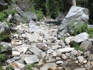
If those two attempts were not enough adventure, we decided to take the back way to the town of Gunnison (where I had thoughts of eating Chinese for lunch).  According to the GPS we were on an off roading trail, but soon we would be on just a trail. Ummm, a trail made for ATVs.


In the 7 years that we have been off-roading in the many different forests, we have never been on a trail with such large boulders and narrow passages.  At 1 - 2 mph it was going to take us a while to get out of the woods. I could walk faster on portions of the trail…therefore taking pictures and video of the excursion from outside of the Jeep.

We may have to change the license plates to MT MULE (Mountain Mule).

Once we were back on pavement (we did make it to Gunnison…and yes, I did get Chinese food, for dinner), we still had to move slowly because it was time for the cows to come home. There were a couple of miles of different herds all heading the same way.

Oh, and just for fun ... if we win the lottery, I kind of like this house we passed on the way back to the RV from Gunnison.
And our final plan of the day was for the Vacation Enthusiast to enjoy some of his favorite things about camping… a view of the mountains, a fire and some Johnsonville cheese bratwursts.

Monday, June 20, 2011

June 19th-20th

Third time's a charm…Quincy’s Steak House! Yes, we were there 3 times in less than a week. On Sunday thru Thursday they serve filet mignon, filet mignon, or filet mignon...your choice. That is the only thing they offer for dinner but you do get your choice of 6oz, 9oz, 12oz, or 15oz. So, of course you order the 15oz for $15! They have this down, make one thing and make it the best…it is absolutely delicious, and with the left-overs you get a great steak-n-egg omelet in the morning.


Sunday, June 19, 2011

June 16th-18th

June 16th Mission: to cross over the still closed Tin Cup Pass
On the way to Tin Cup Pass we explored several campgrounds in the National Forest, went by Cascade Falls, and through the small, the very small town of St. Elmo.
St. Elmo consisted of a General Store, ATV shop, and a Ghost Town Bed & Breakfast, but the most entertaining part of the town was the fearless chipmunks and humming birds.
The chipmunks were helping Lars with the photography of their friends.
Up close and personal with the chipmunks.
This chipmunk has definitely not missed a meal.

The vast numbers of humming birds were so use to tourist that they would rest long enough around the feeders for non-blurry pictures to be taken. 
It was about 6 miles to the top of Tin Cup Pass, we were within about a mile and half, but then the snow became too much of a barrier. We attempted the snow but sliding sideways is not good life choice on an undersized, rocky road, so we retreated. It was still a fun afternoon adventure.

June 17th R & R
On Friday we spent time around the RV and admired the beauty of the campground.
June 18th Peaks, Peaks, and More Peaks…Another Jeeping Day
Today we revisited the historic town of Winfield, where we stayed the last time we were in the area (Ahh yes, the 12 miles of road to get back to Winfield… this is the place where we lost a transmission four years ago.) It was still as pretty as ever, but now they have signs that say for 4X4 vehicles (not 37’ RVs).
After Winfield we headed toward Independence Pass that takes you over the mountains to Aspen. Our purpose was not to go to Aspen but to see the Twin Lakes area and see what kind of camping it had to offer.
After Twin Lakes we headed for Leadville where we had spent about 5 days on a previous trip due to the transmission repair to the RV. Leadville is one of the highest inhabited cities in the contiguous United States (at just over 10,000 feet) and the view was 180 degrees of snow-capped mountains. Gorgeous! Mountains for as far as you could see…looking left, center, and right.
We ended today’s journey by going to the well-known Silver Dollar Saloon which was established in 1897. Good burgers, beer, and tunes were on tap for the rest of the afternoon.